

Starting at $299 Per 1 year license
View PricingOverview
What is Canvas X GEO?
Combining a rich graphic toolset with sophisticated geospatial data handling, Canvas X Geo is a geospatial data illustration software designed to work in tandem with Geographic Information Systems.Represent, filter, and integrate a wide range of geospatial data formats in a…
Recent Reviews
Leaving a review helps other professionals like you evaluate Graphics Software
Be the first one in your network to review Canvas X GEO, and make your voice heard!
Get StartedPricing
Canvas X GEO
$299.00
Cloud
Per 1 year license
Canvas X GEO
$719.00
Cloud
Per 3 year license
Entry-level set up fee?
- No setup fee
For the latest information on pricing, visithttps://www.canvasgfx.com/en/pricing
Offerings
- Free Trial
- Free/Freemium Version
- Premium Consulting/Integration Services
Product Details
- About
- Competitors
- Tech Details
What is Canvas X GEO?
Combining a rich graphic toolset with sophisticated geospatial data handling, Canvas X Geo is a geospatial data illustration software designed to work in tandem with Geographic Information Systems.
- Represent, filter, and integrate a wide range of geospatial data formats in a single, powerful application
- Import and work with documents containing over one million objects in high resolution
- Drive seamless data collaboration thanks to numerous outputs, including maps, cross-sections, figures and presentation
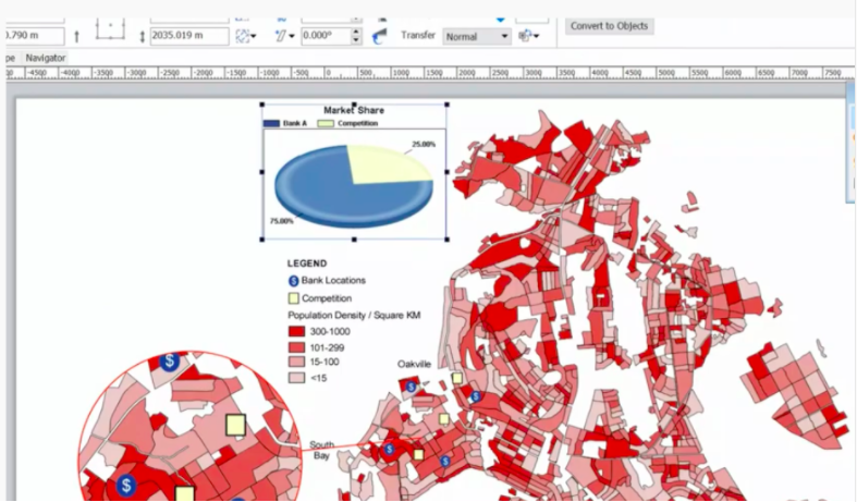
Canvas X GEO Features
- Supported: Real world accuracy: position objects according to their latitude and longitude coordinates. Display the length and forward azimuth when measuring between two points, as well as the percentage of error. Measure distance in real world coordinates by drawing and selecting a line between two points.
- Supported: Granular graticules: create grids displaying the meridians of longitude and parallels of latitude. Precisely control units of measure, exact decimal levels, longitude and latitude start and edit points and spacing/divisions, latitude degree rotation, horizontal and vertical offsets, and even the label format settings.
- Supported: Make your data pop: take advantage of detailed fill, stroke, ink, and custom augmentation options for your GIS data visualization. Vary the appearance of map objects according to a selected property or a query to create thematic and choropleth maps.
Canvas X GEO Screenshots


Canvas X GEO Technical Details
| Deployment Types | Software as a Service (SaaS), Cloud, or Web-Based |
|---|---|
| Operating Systems | Unspecified |
| Mobile Application | No |


