
Overview
What is CyberSWIFT Land Acquisition and management System?
CyberSWIFT Land Acquisition & Management System (LAMS) is a web-based business solution that aims to help organizations manage and monitor large areas of land.This solution is a mix of GIS (Geographic Information System) and MIS (Management Information System) which can…
Leaving a review helps other professionals like you evaluate Geographic Information Systems
Be the first one in your network to review CyberSWIFT Land Acquisition and management System, and make your voice heard!
Get StartedPricing

What is CyberSWIFT Land Acquisition and management System?
CyberSWIFT Land Acquisition & Management System (LAMS) is a web-based business solution that aims to help organizations manage and monitor large areas of land. This solution is a mix of GIS (Geographic Information System) and MIS (Management Information System) which can be used to manage,…
Entry-level set up fee?
- No setup fee
Offerings
- Free Trial
- Free/Freemium Version
- Premium Consulting/Integration Services
Would you like us to let the vendor know that you want pricing?
7 people also want pricing
Alternatives Pricing

What is ArcGIS?
Esri in Redlands, California offers ArcGIS, a geographic information system.

What is QGIS?
QGIS (formerly Quantum GIS) is a free and open source geographic information system.
Product Details
- About
- Competitors
- Tech Details
What is CyberSWIFT Land Acquisition and management System?
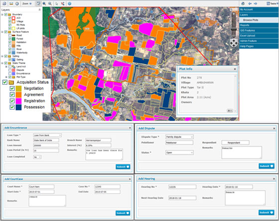
CyberSWIFT Land Acquisition & Management System (LAMS) is a web-based business solution that aims to help organizations manage and monitor large areas of land.
This solution is a mix of GIS (Geographic Information System) and MIS (Management Information System) which can be used to manage, update and monitor land-related data and information. It can also store government records like deeds, plot maps, non-encumbrance certificates, Banda Parcha, Khathiayan, etc. This highly customizable software can also be integrated with map engines like Google Map, Bing Map, Google Earth, etc.
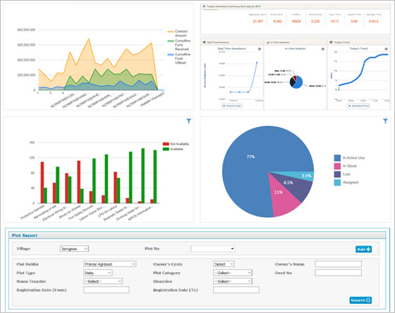
CyberSWIFT Land Acquisition and management System Screenshots
CyberSWIFT Land Acquisition and management System Videos
CyberSWIFT Land Acquisition and management System Competitors
- Tyler SIS
- Pandell
- MaintStar
CyberSWIFT Land Acquisition and management System Technical Details
| Operating Systems | Unspecified |
|---|---|
| Mobile Application | No |