Bing Maps vs. IGiS Desktop (Powered by Scanpoint Geomatics Limited)

Overview
ProductRatingMost Used ByProduct SummaryStarting Price
Bing Maps
Score 7.9 out of 10
N/A
Bing Maps is a geographic information and location intelligence solution, that when integrated as a data visualization dashboard for Microsoft Power BI, Excel, SharePoint and Dynamics software allows organizations to visualize multiple layers of business data on a map, such as sales, current customers and competitors. The ability to view data in this context reveals patterns and relationships, allowing businesses to better understand their opportunities and informs key business decisions at all…N/A
IGiS Desktop (Powered by Scanpoint Geomatics Limited)
Score 7.0 out of 10
N/A
IGiS Desktop provides advanced GIS software for GIS mapping and image processing by aiming to use innovative ways of analyzing, visualizing, and processing geographic data. IGiS Desktop aims to redefine the GIS software industry with integrated GIS mapping, and image processing capabilities with advanced analysis extensions on a single platform. It makes collaboration easy with OGC-supported platforms. Standardized UI and ribbon-based navigation make the user-interface intuitive and…N/A
Pricing
Bing MapsIGiS Desktop (Powered by Scanpoint Geomatics Limited)
Editions & Modules
No answers on this topic
Offerings
Pricing Offerings
Bing MapsIGiS Desktop (Powered by Scanpoint Geomatics Limited)
Free Trial
NoNo
Free/Freemium Version
NoNo
Premium Consulting/Integration Services
NoNo
Entry-level Setup FeeNo setup feeNo setup fee
Additional Details
More Pricing Information
Community Pulse
Bing MapsIGiS Desktop (Powered by Scanpoint Geomatics Limited)
Best Alternatives
Bing MapsIGiS Desktop (Powered by Scanpoint Geomatics Limited)
Small Businesses
ArcGIS
ArcGIS
Score 8.0 out of 10
ArcGIS
ArcGIS
Score 8.0 out of 10
Medium-sized Companies
ArcGIS
ArcGIS
Score 8.0 out of 10
ArcGIS
ArcGIS
Score 8.0 out of 10
Enterprises
ArcGIS
ArcGIS
Score 8.0 out of 10
ArcGIS
ArcGIS
Score 8.0 out of 10
All AlternativesView all alternativesView all alternatives
User Ratings
Bing MapsIGiS Desktop (Powered by Scanpoint Geomatics Limited)
Likelihood to Recommend
7.7
(3 ratings)
-
(0 ratings)
User Testimonials
Bing MapsIGiS Desktop (Powered by Scanpoint Geomatics Limited)
Likelihood to Recommend
Microsoft
Bing Maps is well suited for preplanning loads, specifically in regards to checking the bird's eye and aerial view to see if the facility has enough area or room for overnight parking. And if overnight parking is available, what number of restaurants are within walking distance from the business in the area.
Read full review
Scanpoint Geomatics Limited
No answers on this topic
Pros
Microsoft
  • provides clear directions
  • street views allow preliminary identification of site layout and surrounding services
  • clear background aerial imagery
Read full review
Scanpoint Geomatics Limited
No answers on this topic
Cons
Microsoft
  • Needs to be easier to claim businesses that don't have addresses we can access with mail
  • Easier experience managing multiple properties
  • More collaborative abilities with property managers
Read full review
Scanpoint Geomatics Limited
No answers on this topic
Alternatives Considered
Microsoft
Home Depot and Lowes are both in the same category and offer great products and services but each have something a little different the other doesn't offer or have. Likewise, Bing Maps is in the same category as Google Maps but offers a little something slightly different in the features.
Read full review
Scanpoint Geomatics Limited
No answers on this topic
Return on Investment
Microsoft
  • Makes preliminary identification of sites easy
  • Quick preliminary site layouts
  • Quick and easy to obtain directions
Read full review
Scanpoint Geomatics Limited
No answers on this topic
ScreenShots

IGiS Desktop (Powered by Scanpoint Geomatics Limited) Screenshots
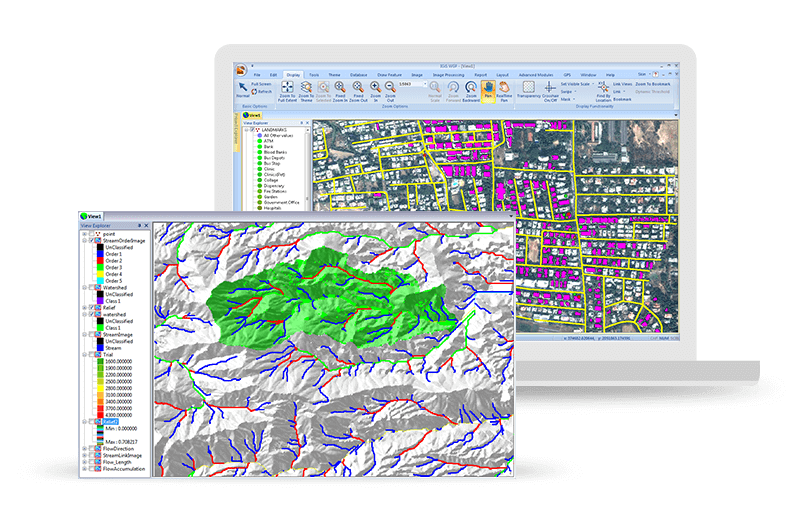
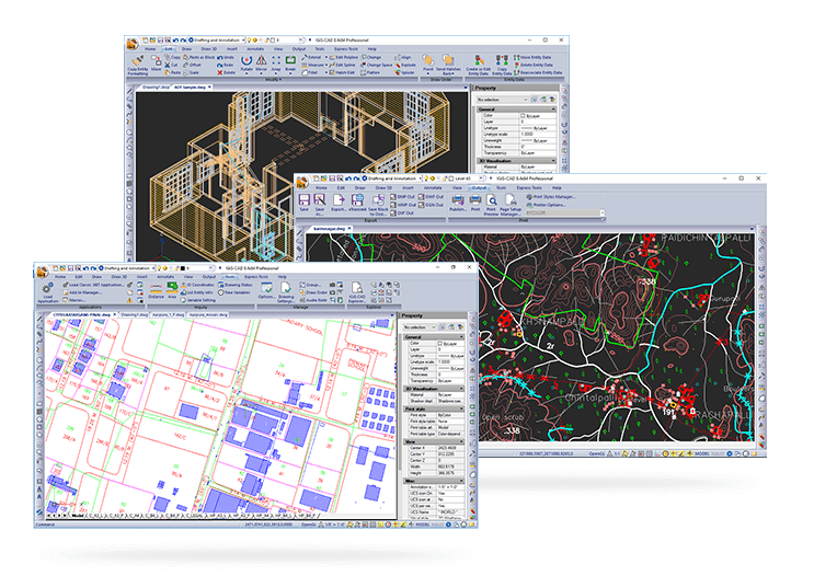
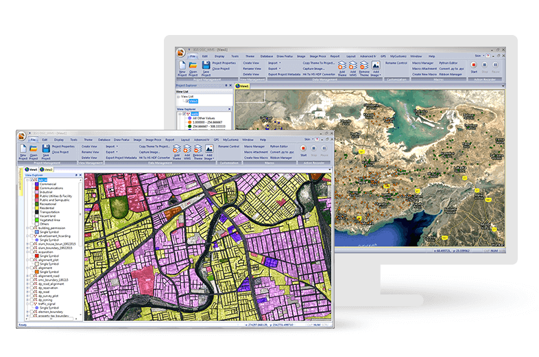
Screenshot of Easily Create, View and Analyse Your Geospatial Data: Next-generation cartographic and visualisation tools for conceptualisation, production, dissemination, and analysis of 2D and 3D maps. It is a 64-bit, Unicode compliant Desktop GIS with an intuitive user interface where data can be viewed in multiple tabs using Multiple Document Interface (MDI).Screenshot of Make Your Life Simpler with Integrated IGiS Software: IGiS aims to redefine the GIS industry with integrated GIS and Image Processing capabilities with advanced analysis extensions on a single platform. Being an OGC compliant platform, makes it easy to collaborate in heterogeneous environment. Standardized UI and ribbon-based navigation makes it easy to use and adapt.Screenshot of Advanced Geo-Processing: IGiS has advanced tools for GIS data conversion, analysis, and visualisation. Advance geospatial users can effectively use tools like Topology creation, Geo-processing, overlay analysis, attribute query builder for desired analysis and output.Screenshot of Efficient Image Processing: IGiS has a rich array of tools and analytical models to analyse and process images. It can manage a multitude of image sources like aerial, satellite, optical, microwave, LIDAR, stereo, GPR, and more. Through smart modelling techniques, IGiS efficiently visualises, analyses, and processes image data, identify patterns, explore changes over time, and carry out scientific analysis to understand spatial relationships.Screenshot of Integrated CAD Tool: IGiS CAD is an extensive mapping tool with cartographic as well as engineering capabilities for mapping real-world objects. IGiS CAD has efficient, fast, user-friendly and feature rich tool to convert and digitize 2D and 3D GIS data. Using Coordinate Geometry (COGO) descriptions, users can accurately create features from any engineering drawing sources and geo-reference them into the GIS database.Screenshot of Manage and Analyse Data Seamlessly: IGiS enables you to store, manage, and edit geospatial data seamlessly. It is a comprehensive tool that supports data integration for a wide range of geospatial data formats including real-time sensor data and big data. Compliance to OGC Standards enables you to store and share data through privileged authentication.