CyberSWIFT Land Acquisition and management System vs. OpenStreetMap
CyberSWIFT Land Acquisition and management System vs. OpenStreetMap
| Product | Rating | Most Used By | Product Summary | Starting Price |
|---|---|---|---|---|
 CyberSWIFT Land Acquisition and management System | N/A | CyberSWIFT Land Acquisition & Management System (LAMS) is a web-based business solution that aims to help organizations manage and monitor large areas of land. This solution is a mix of GIS (Geographic Information System) and MIS (Management Information System) which can be used to manage, update and monitor land-related data and information. It can also store government records like deeds, plot maps, non-encumbrance certificates, Banda Parcha, Khathiayan, etc. This highly customizable… | N/A | |
 OpenStreetMap | N/A | OpenStreetMap, found at openstreetmap.org, is a free and editable map of the world. | N/A |
| CyberSWIFT Land Acquisition and management System | OpenStreetMap | |||||||||||||||
|---|---|---|---|---|---|---|---|---|---|---|---|---|---|---|---|---|
| Editions & Modules | No answers on this topic | No answers on this topic | ||||||||||||||
| Offerings |
| |||||||||||||||
| Entry-level Setup Fee | No setup fee | No setup fee | ||||||||||||||
| Additional Details | — | — | ||||||||||||||
| More Pricing Information | ||||||||||||||||
| CyberSWIFT Land Acquisition and management System | OpenStreetMap | |
|---|---|---|
| Small Businesses |  ArcGIS Score 8.0 out of 10 | ArcGIS Score 8.0 out of 10 |
| Medium-sized Companies | ArcGIS Score 8.0 out of 10 | ArcGIS Score 8.0 out of 10 |
| Enterprises | ArcGIS Score 8.0 out of 10 | ArcGIS Score 8.0 out of 10 |
| All Alternatives | View all alternatives | View all alternatives |
| CyberSWIFT Land Acquisition and management System | OpenStreetMap | |
|---|---|---|
| ScreenShots | CyberSWIFT Land Acquisition and management System Screenshots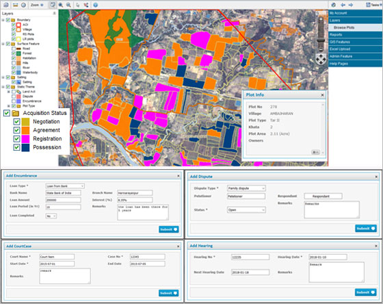 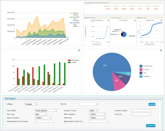 |