Bing Maps vs. CyberSWIFT Land Acquisition and management System
Bing Maps vs. CyberSWIFT Land Acquisition and management System
| Product | Rating | Most Used By | Product Summary | Starting Price |
|---|---|---|---|---|
 Bing Maps | N/A | Bing Maps is a geographic information and location intelligence solution, that when integrated as a data visualization dashboard for Microsoft Power BI, Excel, SharePoint and Dynamics software allows organizations to visualize multiple layers of business data on a map, such as sales, current customers and competitors. The ability to view data in this context reveals patterns and relationships, allowing businesses to better understand their opportunities and informs key business decisions at all… | N/A | |
 CyberSWIFT Land Acquisition and management System | N/A | CyberSWIFT Land Acquisition & Management System (LAMS) is a web-based business solution that aims to help organizations manage and monitor large areas of land. This solution is a mix of GIS (Geographic Information System) and MIS (Management Information System) which can be used to manage, update and monitor land-related data and information. It can also store government records like deeds, plot maps, non-encumbrance certificates, Banda Parcha, Khathiayan, etc. This highly customizable… | N/A |
| Bing Maps | CyberSWIFT Land Acquisition and management System | |||||||||||||||
|---|---|---|---|---|---|---|---|---|---|---|---|---|---|---|---|---|
| Editions & Modules | No answers on this topic | No answers on this topic | ||||||||||||||
| Offerings |
| |||||||||||||||
| Entry-level Setup Fee | No setup fee | No setup fee | ||||||||||||||
| Additional Details | — | — | ||||||||||||||
| More Pricing Information | ||||||||||||||||
| Bing Maps | CyberSWIFT Land Acquisition and management System |
|---|
| Bing Maps | CyberSWIFT Land Acquisition and management System | |
|---|---|---|
| Small Businesses |  ArcGIS Score 8.0 out of 10 | ArcGIS Score 8.0 out of 10 |
| Medium-sized Companies | ArcGIS Score 8.0 out of 10 | ArcGIS Score 8.0 out of 10 |
| Enterprises | ArcGIS Score 8.0 out of 10 | ArcGIS Score 8.0 out of 10 |
| All Alternatives | View all alternatives | View all alternatives |
| Bing Maps | CyberSWIFT Land Acquisition and management System | |
|---|---|---|
| Likelihood to Recommend | 7.7 (3 ratings) | - (0 ratings) |
| Bing Maps | CyberSWIFT Land Acquisition and management System | |
|---|---|---|
| Likelihood to Recommend | Microsoft
| CyberSWIFT No answers on this topic |
| Pros | Microsoft
| CyberSWIFT No answers on this topic |
| Cons | Microsoft
| CyberSWIFT No answers on this topic |
| Alternatives Considered | Microsoft
| CyberSWIFT No answers on this topic |
| Return on Investment | Microsoft
| CyberSWIFT No answers on this topic |
| ScreenShots | CyberSWIFT Land Acquisition and management System Screenshots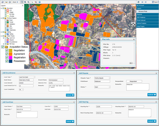 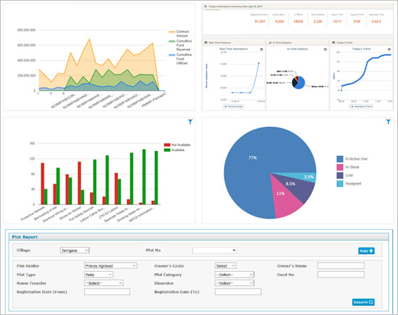 |