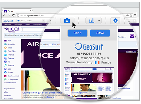
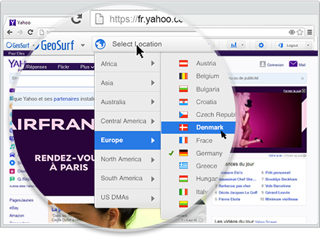
GeoSurf is browser toolbar that enables users to get the local perspective from more than 110 global locations. It is often used by online media professionals (buyers, campaign managers, sales, affiliates, and compliance teams) to view geo-targeted ads and web content. This way, they can easily validate and monitor campaigns, see who is bidding on localized ad placements, generate new sources of business, and enhance current marketing activities. The interface is a straight-forward toolbar which…
$89
month
QGIS
Score 8.0 out of 10
N/A
QGIS (formerly Quantum GIS) is a free and open source geographic information system.
N/A
Pricing
GeoSurf
QGIS
Editions & Modules
Gold Package
$89
month
Platinum Package
$139
month
Diamond Package
$199
month
QGIS
Free
Offerings
Pricing Offerings
GeoSurf
QGIS
Free Trial
No
No
Free/Freemium Version
No
Yes
Premium Consulting/Integration Services
Yes
No
Entry-level Setup Fee
No setup fee
No setup fee
Additional Details
Interested in Enterprise plan? Contact the vendor for details.
For what my team uses GeoSurf for, it is well suited for jumping from country to country to quality control content placements very quickly. For the most part it is reliable, efficient and fast, changing countries and loading content instantly. Our company uses it for a fairly specific task on only our company website, but for what we use it for, it is a very powerful tool.
Styling: the styling engine is fantastic with raster styling features that I recognize from apps like Photoshop.
Print layouts: I can set up custom print layouts, and even do automated multi-page atlas style reports that I use for cycling through detailed areas when providing my clients with pdf reports.
Extendable: the plugins are fantastic, and almost anything I need that isn't provided natively with QGIS is available as a plugin.
Community: the QGIS community is passionate about GIS, and are always ready to help. There are great training resources available online.
It has been very difficult to set up GeoSurf for a device like an Xbox or Playstation, requiring significant experimentation and multiple devices daisy-chained and we needed to write detailed integration guides for testers. Device-specific solutions or guides would help tremendously.
Making maps in QGIS is a bit clunky. I also find it to be extremely unintuitive. For basic GIS, it is great, but I would much rather make maps (for publication purposes) in ArcGIS.
Editing and adding feature layers is not very intuitive. Changing colors of added point or line features is a rather convoluted process.
ArcGIS has a huge selection of online courses, and if you have the appropriate license, you can access most for free. I found these to be very helpful when dealing with map projections and other issues. However, QGIS does not have a large library of courses specifically made for that program.
I wasn't a GIS user at all when I started using QGIS, nor did I have any background working with data in anything other than Excel, and as a result, I struggled quite a lot in the beginning (it's not quite Google Maps). But having said that, I haven't come across anything that I couldn't do with a little help from the online community. I've done complex spatial analyses on large datasets of metropolitan cities, designed custom multi-page pdf reports that automatically cycle through different areas of an area, etc.
And the GIS staff that I've appointed, after their initial resistance, took to the tool like a fish to water, and I haven't heard them complain after starting to use the tool for a week or two.
But if you're new to GIS, be patient and invest some time to learn how to use the tool. It is absolutely worth it.
Even though there is a no dedicated support team for QGIS (or at least we are not aware of it), there is a huge online community and a large number of forums catering to every question you may have regarding any particular functionality of QGIS. So, you have a lot of help available but you will have to sift through it on the web.
Geosurf blows them out of the water in terms of features and liability. Freedom offers a cheaper cost but when you are working for a big company it is time to bring out the big guns and that is where GeoSurf comes in. Reliable is an understatement for sure.
QGIS is open source and freely available for Windows and Mac iOS Geographic Information System Software. QGIS is highly customizable as per project requirements and different application usage. QGIS has ample tools and plugins that are useful for the analysis of raster and vector data. It also supports GRASS, GDAL, and SAGA tools.
QGIS gives us more impactful data on children and maternal health issues, which in turn has helped us establish more programs, relationships, and funding opportunities because of the excellent data presentations we can give.
QGIS has allowed our staff to improve their data analysis skills, improving our workforce across the board, with or without the direct use of geographic data.
QGIS has required a lot of staff time to learn, but the ROI on time spent vs the reports we produced afterward has been well worth it.