Oracle Cloud Infrastructure (OCI) is Oracles's infrastructure-as-a-service (IaaS) platform which combines the utility of public cloud with the granular control, security, and predictability of on-premises infrastructure.
N/A
QGIS
Score7.6 out of 10
N/A
QGIS (formerly Quantum GIS) is a free and open source geographic information system.
As per our usage Oracle Cloud Infrastructure for almost 6 years hosting 500 + customers I can say its well suited application for any small scale to larger scale application as it can handle that capacity and provide more reliable cloud service only if you need any messaging service like pub/sub or sqs better to consider other services.
A de minimis incentive was given to thank the reviewer for their time. The incentive was not used to bias or drive a particular response, nor was the incentive contingent on a positive endorsement. More Info
A de minimis incentive was given to thank the reviewer for their time. The incentive was not used to bias or drive a particular response, nor was the incentive contingent on a positive endorsement. More Info
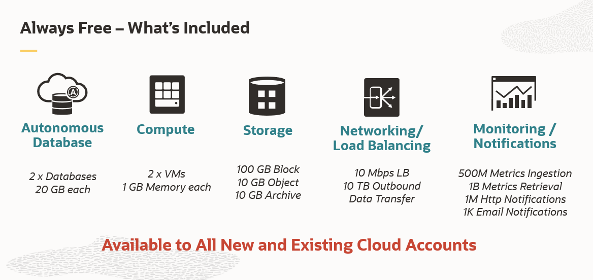
Oracle Cloud Infrastructure has a generous free tier, moreso than other hyperscalers, with an always-free tier that guarantees certain products are always free
Oracle Cloud Infrastructure allows you to size VMs with differing combinations of CPU and RAM, which is contrary to other hyperscalers that have specific pre-defined combinations only
A de minimis incentive was given to thank the reviewer for their time. The incentive was not used to bias or drive a particular response, nor was the incentive contingent on a positive endorsement. More Info
Styling: the styling engine is fantastic with raster styling features that I recognize from apps like Photoshop.
Print layouts: I can set up custom print layouts, and even do automated multi-page atlas style reports that I use for cycling through detailed areas when providing my clients with pdf reports.
Extendable: the plugins are fantastic, and almost anything I need that isn't provided natively with QGIS is available as a plugin.
Community: the QGIS community is passionate about GIS, and are always ready to help. There are great training resources available online.
A de minimis incentive was given to thank the reviewer for their time. The incentive was not used to bias or drive a particular response, nor was the incentive contingent on a positive endorsement. More Info
Navigating the UI takes lots of getting used to. It reminds me of older GCP (just to get used to where everything is).
Permission for different things always seemed to be more difficult than it really needed to be. Once you got them set up you were good but updating anything or creating new permissions for just about anything took longer than I thought it should.
Based on how the buttons were laid out, it was pretty easy to delete all of your DNS records, and backing them up was not as intuitive as I'd like with the UI, but it was easy to do using a script.
A de minimis incentive was given to thank the reviewer for their time. The incentive was not used to bias or drive a particular response, nor was the incentive contingent on a positive endorsement. More Info
Making maps in QGIS is a bit clunky. I also find it to be extremely unintuitive. For basic GIS, it is great, but I would much rather make maps (for publication purposes) in ArcGIS.
Editing and adding feature layers is not very intuitive. Changing colors of added point or line features is a rather convoluted process.
ArcGIS has a huge selection of online courses, and if you have the appropriate license, you can access most for free. I found these to be very helpful when dealing with map projections and other issues. However, QGIS does not have a large library of courses specifically made for that program.
A de minimis incentive was given to thank the reviewer for their time. The incentive was not used to bias or drive a particular response, nor was the incentive contingent on a positive endorsement. More Info
Reliability: Very dependable and stable OCI services have been for the business operations.Performance: The speed and efficiency of OCI in meeting their computing and storage needs.Scalability: The ease and effectiveness of scaling resources up or down to accommodate changing demands.Security: The robustness and effectiveness of OCI's security features in protecting their data and applications.
A de minimis incentive was given to thank the reviewer for their time. The incentive was not used to bias or drive a particular response, nor was the incentive contingent on a positive endorsement. More Info
The services & products in Oracle Cloud Infrastructure needs more improvement to beat other Cloud service providers. The price is good & Security processes are good. We are requiring to put more effort in supporting this Oracle Cloud Infrastructure than other Cloud service providers. Probably better ways are there but is not super easy to find or not super available
I wasn't a GIS user at all when I started using QGIS, nor did I have any background working with data in anything other than Excel, and as a result, I struggled quite a lot in the beginning (it's not quite Google Maps). But having said that, I haven't come across anything that I couldn't do with a little help from the online community. I've done complex spatial analyses on large datasets of metropolitan cities, designed custom multi-page pdf reports that automatically cycle through different areas of an area, etc.
And the GIS staff that I've appointed, after their initial resistance, took to the tool like a fish to water, and I haven't heard them complain after starting to use the tool for a week or two.
But if you're new to GIS, be patient and invest some time to learn how to use the tool. It is absolutely worth it.
A de minimis incentive was given to thank the reviewer for their time. The incentive was not used to bias or drive a particular response, nor was the incentive contingent on a positive endorsement. More Info
Yeah sometimes we had to face unplanned outages due to underlying infrastructure issues, so not every time,e but once in a while we face issues with availability. But the good thing is we have redundancy with DR setup and multi region so we can manage.
A de minimis incentive was given to thank the reviewer for their time. The incentive was not used to bias or drive a particular response, nor was the incentive contingent on a positive endorsement. More Info
From the start, I was surprised by response times and image quality accessing windows VMs with RDP. GCP, Azure and -many offerings in AWS- don't perform this speed. Also, that's evident in the quality of Infrastructure Management Team, because I just received one warning regarding a region failure, what confirms that's a mature platform.
A de minimis incentive was given to thank the reviewer for their time. The incentive was not used to bias or drive a particular response, nor was the incentive contingent on a positive endorsement. More Info
Overall it is amazing, there is always room for improvement. We have weekly updates that tend to slow the program used more and more. We had to change some reports within Oracle because the others wouldn’t load. This is tied to our payroll and the delays are causing many time constraint issues and panic. We have to create a new report when one breaks. Otherwise awesome!
A de minimis incentive was given to thank the reviewer for their time. The incentive was not used to bias or drive a particular response, nor was the incentive contingent on a positive endorsement. More Info
Even though there is a no dedicated support team for QGIS (or at least we are not aware of it), there is a huge online community and a large number of forums catering to every question you may have regarding any particular functionality of QGIS. So, you have a lot of help available but you will have to sift through it on the web.
A de minimis incentive was given to thank the reviewer for their time. The incentive was not used to bias or drive a particular response, nor was the incentive contingent on a positive endorsement. More Info
A de minimis incentive was given to thank the reviewer for their time. The incentive was not used to bias or drive a particular response, nor was the incentive contingent on a positive endorsement. More Info
A de minimis incentive was given to thank the reviewer for their time. The incentive was not used to bias or drive a particular response, nor was the incentive contingent on a positive endorsement. More Info
A de minimis incentive was given to thank the reviewer for their time. The incentive was not used to bias or drive a particular response, nor was the incentive contingent on a positive endorsement. TR verified that a representative sample of customers was invited. More Info
We used Microsoft Azure and Docker earlier and faced some difficulties like Microsoft Azure and Docker. Occasionally, the generation of large images can delay deployment. It is also necessary for me to admit that Microsoft Azure and Docker have a somewhat steep learning curve. Proper paperwork needs to be there. Docker has issues with performance on a number of platforms. On the other hand, OCI is easy to deploy and easy to understand.
A de minimis incentive was given to thank the reviewer for their time. The incentive was not used to bias or drive a particular response, nor was the incentive contingent on a positive endorsement. More Info
QGIS is open source and freely available for Windows and Mac iOS Geographic Information System Software. QGIS is highly customizable as per project requirements and different application usage. QGIS has ample tools and plugins that are useful for the analysis of raster and vector data. It also supports GRASS, GDAL, and SAGA tools.
A de minimis incentive was given to thank the reviewer for their time. The incentive was not used to bias or drive a particular response, nor was the incentive contingent on a positive endorsement. More Info
was not part of initial purchase team. Anyways, i think unit pricing and billing frequency is good compared to other Cloud service providers, when it comes to Cloud Capital expenditure & Operational expenditure. Would be more interested in exploring more options where customers can get more cost relaxations on trying out new cloud services in Oracle Cloud Infrastructure for example a new App or a feature
We have hosted around 500 + customers on this cloud so till day not faced any major issues, so we can use it for any kind of products and it can hold the load and easily scale based on need.
A de minimis incentive was given to thank the reviewer for their time. The incentive was not used to bias or drive a particular response, nor was the incentive contingent on a positive endorsement. More Info
Services & Infra wise is ok to use & host applications & services. Security wise also good for a Cloud service provider. It is a interesting area to explore & using it for day to day needs can be further improvised in future probably. Modern day Services like AI and Machine learning could be improved
A de minimis incentive was given to thank the reviewer for their time. The incentive was not used to bias or drive a particular response, nor was the incentive contingent on a positive endorsement. TR verified that a representative sample of customers was invited. More Info
QGIS gives us more impactful data on children and maternal health issues, which in turn has helped us establish more programs, relationships, and funding opportunities because of the excellent data presentations we can give.
QGIS has allowed our staff to improve their data analysis skills, improving our workforce across the board, with or without the direct use of geographic data.
QGIS has required a lot of staff time to learn, but the ROI on time spent vs the reports we produced afterward has been well worth it.
A de minimis incentive was given to thank the reviewer for their time. The incentive was not used to bias or drive a particular response, nor was the incentive contingent on a positive endorsement. More Info