ArcGIS vs. CyberSWIFT Land Acquisition and management System

Overview
ProductRatingMost Used ByProduct SummaryStarting Price
ArcGIS
Score 8.0 out of 10
N/A
Esri in Redlands, California offers ArcGIS, a geographic information system.
$100
per year
CyberSWIFT Land Acquisition and management System
Score 0.0 out of 10
N/A
CyberSWIFT Land Acquisition & Management System (LAMS) is a web-based business solution that aims to help organizations manage and monitor large areas of land. This solution is a mix of GIS (Geographic Information System) and MIS (Management Information System) which can be used to manage, update and monitor land-related data and information. It can also store government records like deeds, plot maps, non-encumbrance certificates, Banda Parcha, Khathiayan, etc. This highly customizable…N/A
Pricing
ArcGISCyberSWIFT Land Acquisition and management System
Editions & Modules
Viewer
$100
per year
ArcGIS for Personal Use
$100
per year
ArcGIS for Student Use
$100
per year
Editor
$200
per year
Field Worker
$350
per year
Creator
$500
per year
GIS Professional Basic
$700
per year
GIS Professional Basic
2,750
per year
GIS Professional Advanced
3,800
per year
No answers on this topic
Offerings
Pricing Offerings
ArcGISCyberSWIFT Land Acquisition and management System
Free Trial
NoNo
Free/Freemium Version
NoNo
Premium Consulting/Integration Services
NoNo
Entry-level Setup FeeNo setup feeNo setup fee
Additional Details
More Pricing Information
Community Pulse
ArcGISCyberSWIFT Land Acquisition and management System
Best Alternatives
ArcGISCyberSWIFT Land Acquisition and management System
Small Businesses
Google Maps API
Google Maps API
Score 8.8 out of 10
ArcGIS
ArcGIS
Score 8.0 out of 10
Medium-sized Companies
Google Maps API
Google Maps API
Score 8.8 out of 10
ArcGIS
ArcGIS
Score 8.0 out of 10
Enterprises
Google Maps API
Google Maps API
Score 8.8 out of 10
ArcGIS
ArcGIS
Score 8.0 out of 10
All AlternativesView all alternativesView all alternatives
User Ratings
ArcGISCyberSWIFT Land Acquisition and management System
Likelihood to Recommend
8.0
(40 ratings)
-
(0 ratings)
Likelihood to Renew
8.0
(1 ratings)
-
(0 ratings)
Usability
8.0
(3 ratings)
-
(0 ratings)
Support Rating
9.1
(12 ratings)
-
(0 ratings)
User Testimonials
ArcGISCyberSWIFT Land Acquisition and management System
Likelihood to Recommend
Esri
I'm very grateful to be able to use it, and I have a master's degree with a focus in Geospatial Analysis. There can be a bit of a learning curve, and I try to build user-friendly ways for volunteers to see & collect data. Meanwhile, if a colleague is less confident with building such a system, it may be more difficult for them to implement.
Read full review
CyberSWIFT
No answers on this topic
Pros
Esri
  • Enterprise GIS - multi-user, multi-versioned geodatabase access through a host of apps and web tools really help people stay connected to data.
  • Cartography - fantastic control and customization available with the ability to automate workflows.
  • Training - tons of training videos, seminars, and other learning materials are easily accessed. The help documentation is superb.
  • Ability to manage an organization through dashboards is extremely helpful.
Read full review
CyberSWIFT
No answers on this topic
Cons
Esri
  • There is a steep learning curve for ArcGIS users.
  • It takes a lot of computing power for ArcGIS, as it can't be installed on every computer.
  • At times, tools can be outdated and there are many similar competitors making more web-based tools that can replace ArcGIS.
Read full review
CyberSWIFT
No answers on this topic
Likelihood to Renew
Esri
Simply because the program deserves it. It seems to me that it is a fundamental tool for the storage, analysis, and interpretation of medium and large-scale phenomena, unmanageable with traditional engineering software. Its versatility in the handling of the different "layers" with which the data is handled and interpolation tools, make this software a powerful ally both for companies and for the educational part of the universities.
Read full review
CyberSWIFT
No answers on this topic
Usability
Esri
Once set up, the tools are extremely easy to use. I had a staff member develop a tool for field data collection, that included an external and internal dashboards to monitor progress in days. The field workers that collected the data, barely knew how to use a computer, and within minutes they could use the application that was configured for them.
Read full review
CyberSWIFT
No answers on this topic
Support Rating
Esri
Unlike other platforms (ex: EMSI), there is no "help desk" new users can easily call into for troubleshooting or errors, and so you have to spend LOTS of time trying workarounds. This is also because the help center blog posts are usually pretty confusing, and many times do not include images or videos to help you along. Any such changes would be immensely useful!
Read full review
CyberSWIFT
No answers on this topic
Alternatives Considered
Esri
My students love the "drop" feature in Google Maps, but besides that it truly doesn't compare. I love that you can add, delete, or change layers to this map to better understand its larger affect. There are many more ways to manipulate maps on ArcGIS than on Google Maps. I can also add personal details and information if I want to create a specific map, something that I am unable to do with Google
Read full review
CyberSWIFT
No answers on this topic
Return on Investment
Esri
  • ArcGIS saves us countless hours of manual paperwork by allowing us to conduct inspections in the field.
  • Due to the high upfront costs, the ROI will definitely take longer than other competing products
  • The PDF export feature allows us to share our maps with the public while maintaining control of the data associated with the map.
Read full review
CyberSWIFT
No answers on this topic
ScreenShots

CyberSWIFT Land Acquisition and management System Screenshots
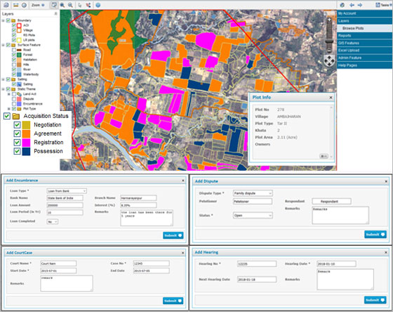
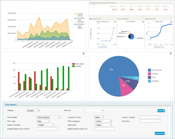
Screenshot of LAMS assists users through every stage of land acquisition/purchase by providing detailed land-related information, payment modules, obligations, etc.
Supports macro to micro level monitoring of every individual plot from Pre-Land Acquisition to Post Land Acquisition.Screenshot of Extensive query execution and shows accurate results by drilling down data on the map.
The land status as shown on the map is constantly updated to ensure that the information provided is correct.