
Ardath Dixon
Stewardship Manager
Chose ArcGIS
QGIS, Leaflet, OpenStreetMap and Mapbox
| Product | Rating | Most Used By | Product Summary | Starting Price |
|---|---|---|---|---|
 ArcGIS | N/A | Esri in Redlands, California offers ArcGIS, a geographic information system. | $100 per year | |
 MAPOG | N/A | MAPOG is a mapping platform that transforms locations, projects, portfolios, and data into interactive visual maps. Instead of scattered files or reports, users can import data from CSV or Excel and display every site on a single map with photos, videos, links, and key details for each point. Users can add custom base maps using geo-referencing to showcase campuses, layouts, or property overviews, and use bearing angle measurement for navigation, planning, or… | $9 per month per user |
| ArcGIS | MAPOG | |||||||||||||||
|---|---|---|---|---|---|---|---|---|---|---|---|---|---|---|---|---|
| Editions & Modules |
|
| ||||||||||||||
| Offerings |
| |||||||||||||||
| Entry-level Setup Fee | No setup fee | No setup fee | ||||||||||||||
| Additional Details | — | Pro Plan: Best for individuals, startups, or small teams. Includes up to 10 maps, 1,000 story points, basic geocoding, and AI-powered story creation. Monthly: $9.0/month Annual: $7.5/month ($90/year, save up to 40% with annual billing) Business Plan: Ideal for growing teams needing more maps, data points, advanced geocoding, layer tools, and GIS AI queries. Monthly: $21.0/month Annual: $21/month ($252/year, save up to 40% with annual billing) Business+ Plan: Designed for large enterprises with unlimited maps, up to 1,000,000 story points, 8 GB storage, enterprise-grade collaboration, and premium support. Monthly: $99.0/month Annual: $58/month ($696/year, save up to 40% with annual billing) Additional Users: Add team members for $5.63/month | ||||||||||||||
| More Pricing Information | ||||||||||||||||
| ArcGIS | MAPOG | |
|---|---|---|
| Considered Both Products | ArcGIS Ardath Dixon Stewardship Manager Chose ArcGIS QGIS, Leaflet, OpenStreetMap and Mapbox  Deveshan Govender Civil Engineering Technician Chose ArcGIS I haven't used any other software similar to GIS.  Rachel Piper Middle School Humanities Teacher Chose ArcGIS My students love the "drop" feature in Google Maps, but besides that it truly doesn't compare. I love that you can add, delete, or change layers to this map to better understand its larger affect. There are many more ways to manipulate maps on ArcGIS than on Google Maps. I can …  Charles Tremblay Biologist Chose ArcGIS I was working with this software fore more than 10 years. I learned ArcGIS at University and I believed this software to be essential in the management of GIS. It was before I tried QGIS. I regret my purchase by the expensive cost, the complex method to licencing and the weak …  Yoni Dvorkis Lead Data Scientist Chose ArcGIS ArcGIS is the only tool we have the geocodes addressed on premises without sending data over the internet. We could have explored that option with Spotfire but it was out of our price range. I also tried to do this manually using PostgreSQL which also has a free implementation …  Gabriella Lott Research Analyst Chose ArcGIS ArcGIS is way more useful, especially in terms of bringing in non-ACS data. However, if we are in a rush, sometimes our firm will just make Social Explorer maps to easily get the point across. It's not really a comparison, though, and ESRI definitely has the field on lock …  Arron Davis GIS Technician Chose ArcGIS I have used other free use GIS programs and even some online apps but none can compare to the amount of functionality as ArcGIS. ArcGIS has all the features and ease of use to manage and look at data that most programs lack.  Scott McGee Information Technology Manager Chose ArcGIS ArcGIS and QGIS have a lot of similarities between their products. Where ArcGIS stands out is with their online version of their software. ArcGIS's online solution will pair up with your on-prem solution to offer a fully synchronized system. I wasn't able to duplicate the …  John Michael Callen Geologist Chose ArcGIS ArcGIS does not have some of the geologic data mapping capabilities and tuning capabilities of Geographix, but in almost every other way, from map quality, manipulation of map properties, speed, and ease of use, I find ArcGIS far superior.  FRANCO PIÑERO Ingeniero de proyecto Chose ArcGIS In my opinion ArcGIS is the most comprehensive geographic information system program in the world, select it over QGIS because it contains all the tools for a proper planning of the territory. arcgis offers the best geo-statistics tools, automated cartography, maps …  Shelby Bowden Graduate Research Assistant Chose ArcGIS ArcGIS is overall a better program than most of the competitors. It is generally more user-friendly, has better displays, and more customization than other programs. It is especially useful in the geosciences and workplace settings, where data can be seamlessly shared among …  Rafael Mejias Analista Chose ArcGIS I have used the GVSIG software, but I decided to stay with ArcGIS because it seems more complete and functional. With ArcGIS I have many more analysis tools, such as Arc toolbox. The management of statistics within the software seems great, as well as the possibility of …  Andres Meza Ingeniero Chose ArcGIS Select ArcGIS because it is a work tool for professional recognition of experts linked to the geography and planning of the territory. It is a very complete program because it allows you to debug content, georeference, analyze content, and cartography design. It is the best … |  MAPOG No answer on this topic |
| ArcGIS | MAPOG | |
|---|---|---|
| Small Businesses |  Google Maps API Score 8.9 out of 10 | ArcGIS Score 7.9 out of 10 |
| Medium-sized Companies | Google Maps API Score 8.9 out of 10 | ArcGIS Score 7.9 out of 10 |
| Enterprises | Google Maps API Score 8.9 out of 10 | ArcGIS Score 7.9 out of 10 |
| All Alternatives | View all alternatives | View all alternatives |
| ArcGIS | MAPOG | |
|---|---|---|
| Likelihood to Recommend | 8.0 (0 ratings) | - (0 ratings) |
| Likelihood to Renew | 8.0 (0 ratings) | - (0 ratings) |
| Usability | 8.0 (0 ratings) | - (0 ratings) |
| Support Rating | 9.1 (0 ratings) | - (0 ratings) |
| ArcGIS | MAPOG | |
|---|---|---|
| Likelihood to Recommend |
Ardath Dixon Stewardship Manager | No answers on this topic |
| Pros |
Gabriella Lott Research Analyst | No answers on this topic |
| Cons |
| No answers on this topic |
| Likelihood to Renew |
 Rafael Becemberg Jefe del departamento de Oceanografia | No answers on this topic |
| Usability |
| No answers on this topic |
| Support Rating |
| No answers on this topic |
| Alternatives Considered |
Rachel Piper Middle School Humanities Teacher | No answers on this topic |
| Return on Investment |
| No answers on this topic |
| ScreenShots | MAPOG Screenshots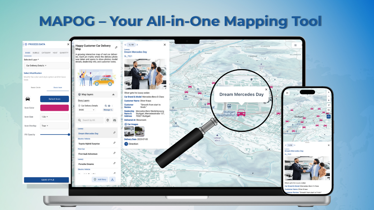 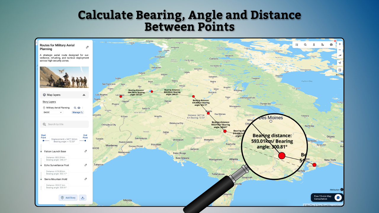  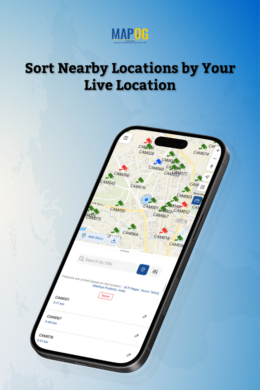 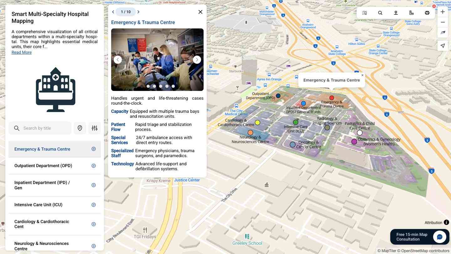 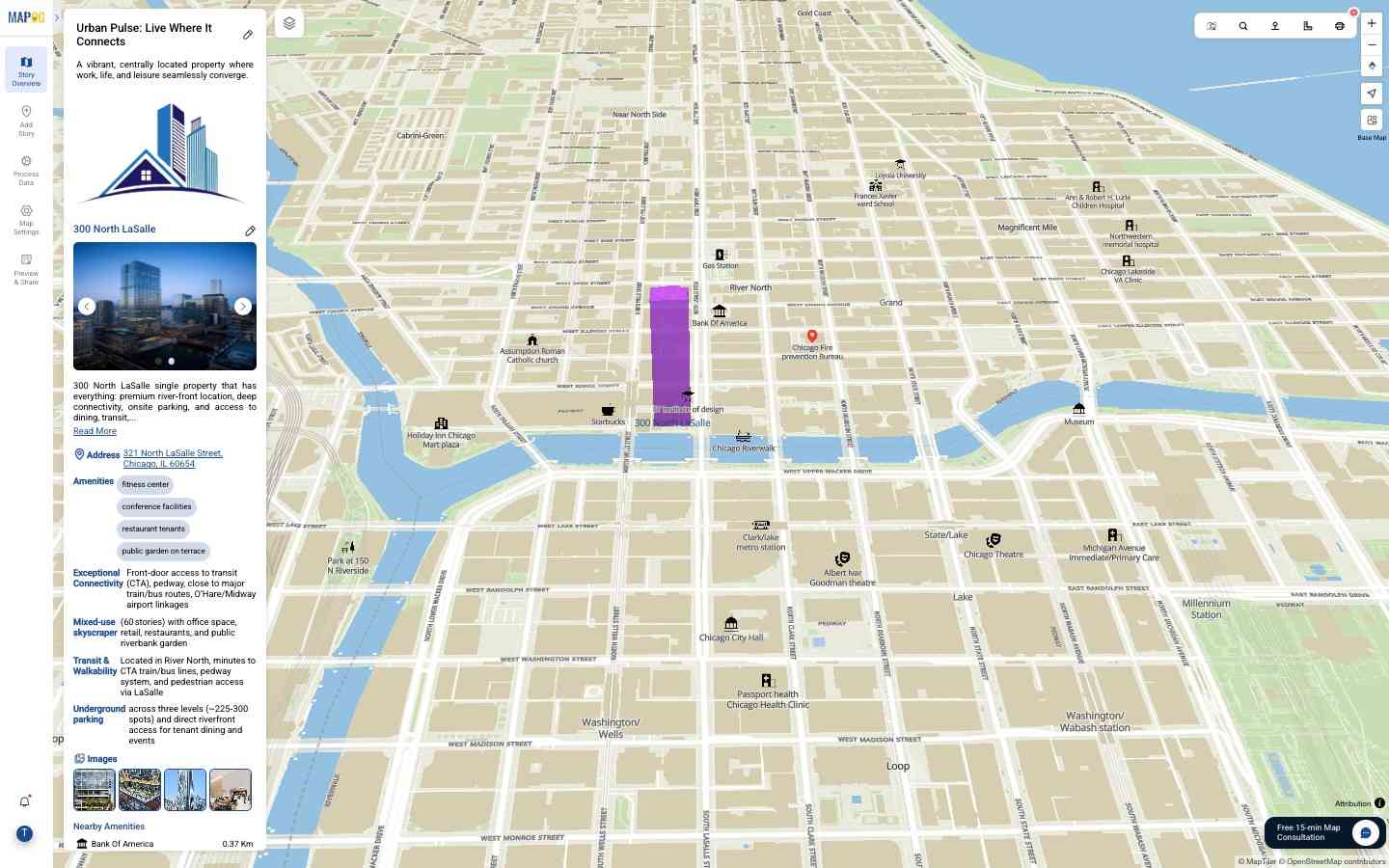 |