Esri in Redlands, California offers ArcGIS, a geographic information system.
$100
per year
WhoisXML API IP Geolocation API
Score 8.0 out of 10
N/A
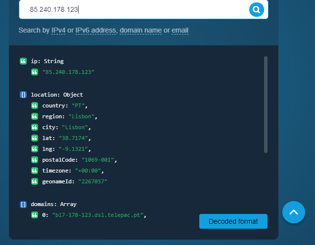
About IP Geolocation API WhoisXML API’s IP Geolocation API is a resource to link an IP address, domain name, or email to its geographical coordinates. For a given input, the API returns various location data points among which the country, city, time zone, postal code, latitude and longitude, ASN type, geoname ID, ISP, as well as associated domains. Marketing Marketers and advertising professionals can use the API to enrich customer profiles with location…
I'm very grateful to be able to use it, and I have a master's degree with a focus in Geospatial Analysis. There can be a bit of a learning curve, and I try to build user-friendly ways for volunteers to see & collect data. Meanwhile, if a colleague is less confident with building such a system, it may be more difficult for them to implement.
On our end, we've mostly used IP Geolocation API for cybersecurity purposes. A particular scenario that comes to mind is when suspicious IP addresses make it to our site from locations we wouldn't expect. In this context, the API integrated into our existing infosec solutions helps us spot those IP addresses so we can decide how to sort them. Also, say that one of our employees receive a phishing email or one that contains a possible malware file. We can use IP Geolocation API to enrich what we know about a sender and add the related IP address to our blocklist if necessary.
Aside from identifying the physical location of an IP address owner, the API also provides users with its Internet service provider and connection type. That is handy information if website owners wish to customize their site loading to match the connection speed of the majority of their visitors.
It doesn’t matter whether website visitors use an IPv4 or IPv6 address in that the API works for both spaces. The records in the API’s database are also updated weekly, so users always get the latest results.
Like most, if not all, IP geolocation services, it does not provide very accurate information down to the street level address. But since we do most of our business transactions online, that doesn’t pose much of a problem for us.
Simply because the program deserves it. It seems to me that it is a fundamental tool for the storage, analysis, and interpretation of medium and large-scale phenomena, unmanageable with traditional engineering software. Its versatility in the handling of the different "layers" with which the data is handled and interpolation tools, make this software a powerful ally both for companies and for the educational part of the universities.
Once set up, the tools are extremely easy to use. I had a staff member develop a tool for field data collection, that included an external and internal dashboards to monitor progress in days. The field workers that collected the data, barely knew how to use a computer, and within minutes they could use the application that was configured for them.
Unlike other platforms (ex: EMSI), there is no "help desk" new users can easily call into for troubleshooting or errors, and so you have to spend LOTS of time trying workarounds. This is also because the help center blog posts are usually pretty confusing, and many times do not include images or videos to help you along. Any such changes would be immensely useful!
We had a few questions regarding API set up when we started using IP Geolocation API so we reached out to the support team and they promptly helped us out. We have not experienced any glitch with the product and the data sent to us has always been reliable so far.
My students love the "drop" feature in Google Maps, but besides that it truly doesn't compare. I love that you can add, delete, or change layers to this map to better understand its larger affect. There are many more ways to manipulate maps on ArcGIS than on Google Maps. I can also add personal details and information if I want to create a specific map, something that I am unable to do with Google