Bing Maps is a geographic information and location intelligence solution, that when integrated as a data visualization dashboard for Microsoft Power BI, Excel, SharePoint and Dynamics software allows organizations to visualize multiple layers of business data on a map, such as sales, current customers and competitors. The ability to view data in this context reveals patterns and relationships, allowing businesses to better understand their opportunities and informs key business decisions at all…
N/A
Cisco Spaces
Score8.9 out of 10
N/A
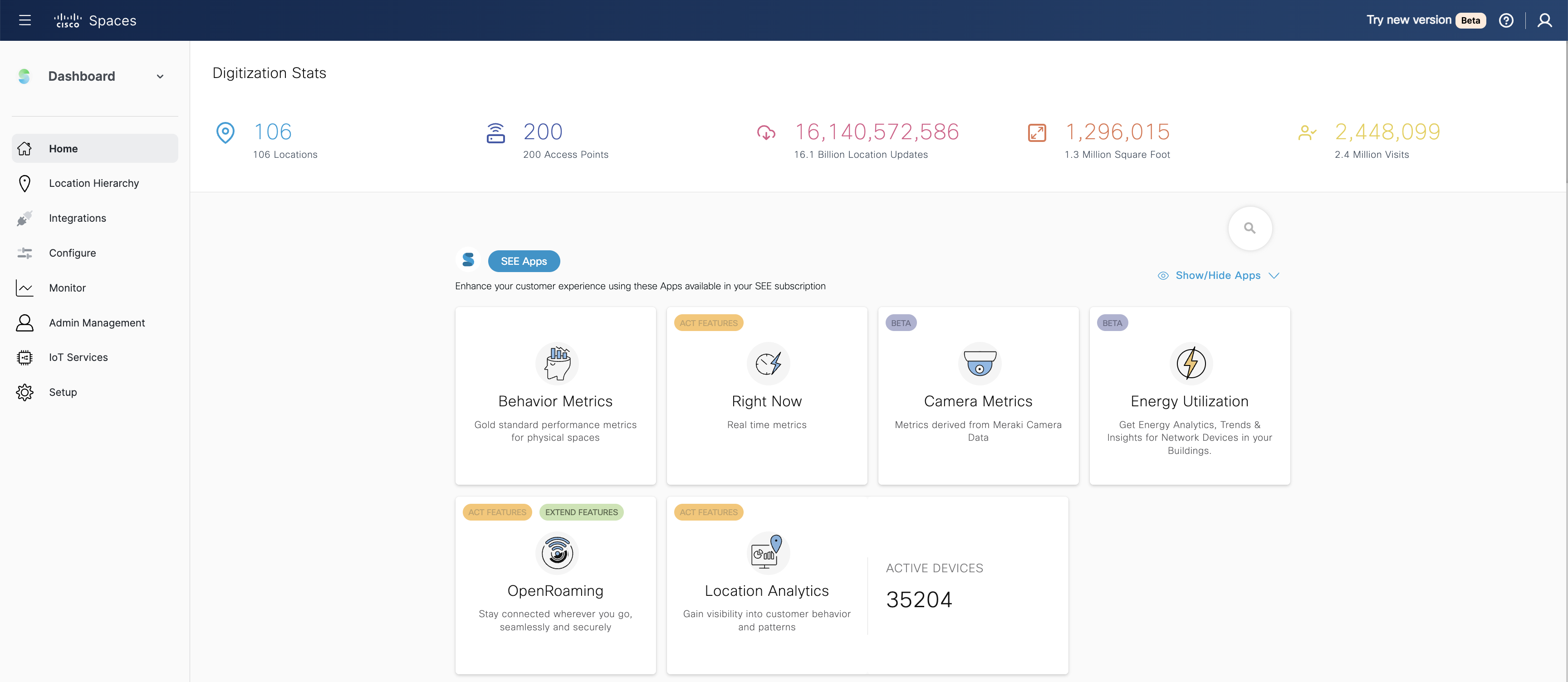
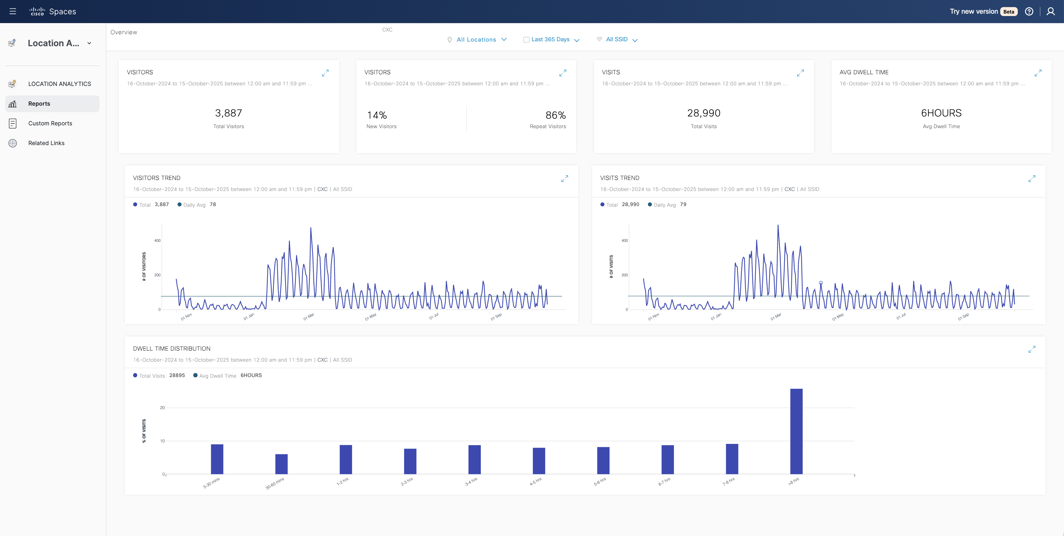
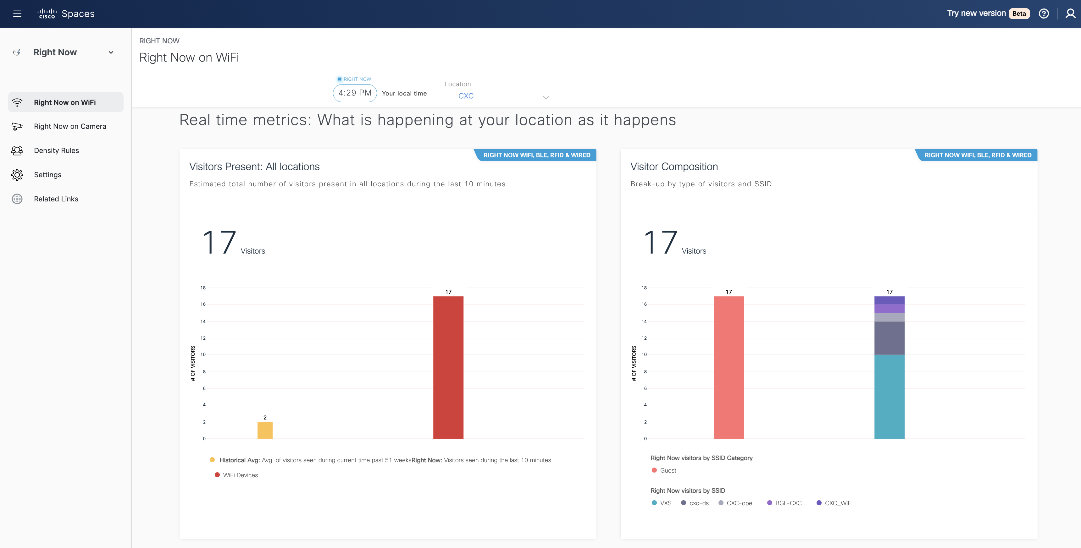
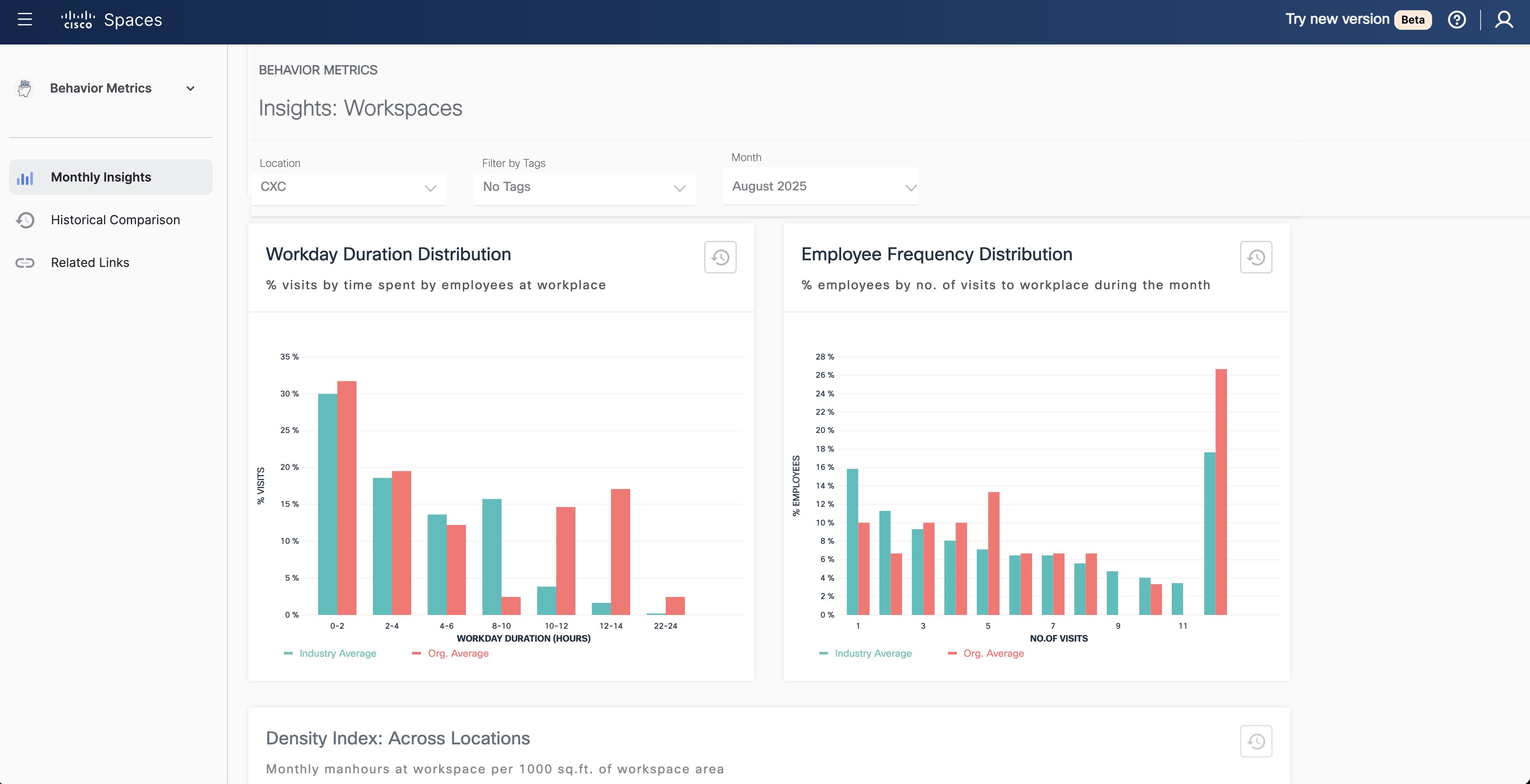
Cisco Spaces is a cloud platform that connects people and things with spaces to transform buildings into smart spaces. Using Cisco devices as sensors (Catalyst, Meraki, Webex) and the Spaces ecosystem, the aim is to make buildings safe, smart, sustainable, and seamless. Currently the platform has digitized 193,781+ buildings, 72,836+ devices and has over 8,000+ global enterprise customers.
N/A
QGIS
Score7.6 out of 10
N/A
QGIS (formerly Quantum GIS) is a free and open source geographic information system.
Bing Maps is well suited for preplanning loads, specifically in regards to checking the bird's eye and aerial view to see if the facility has enough area or room for overnight parking. And if overnight parking is available, what number of restaurants are within walking distance from the business in the area.
A de minimis incentive was given to thank the reviewer for their time. The incentive was not used to bias or drive a particular response, nor was the incentive contingent on a positive endorsement. More Info
I think it's well suited for real estate management teams when they are drowning in data, but they're starting from insights. I think that's most appropriate. It's possibly not the right solution for smaller sites. So if it's very obvious where you need to go or you don't need that visibility because the office is particularly small, it doesn't make sense at all.
A de minimis incentive was given to thank the reviewer for their time. The incentive was not used to bias or drive a particular response, nor was the incentive contingent on a positive endorsement. More Info
A de minimis incentive was given to thank the reviewer for their time. The incentive was not used to bias or drive a particular response, nor was the incentive contingent on a positive endorsement. More Info
A de minimis incentive was given to thank the reviewer for their time. The incentive was not used to bias or drive a particular response, nor was the incentive contingent on a positive endorsement. More Info
So the first thing it does really well is a lot of our sites are rural, so we don't have very good cellular connectivity. So we invested in this product because we want our clients, our customers that are coming in to be able to walk in and be able to use a our wireless infrastructure just like it was a cellular device. So they don't even know, they walk in, they think, man, my cellular's better right now. I can do all the things that I wanna do. I can do video. And they don't even know. So that's the biggest bonus for us.
A de minimis incentive was given to thank the reviewer for their time. The incentive was not used to bias or drive a particular response, nor was the incentive contingent on a positive endorsement. More Info
Styling: the styling engine is fantastic with raster styling features that I recognize from apps like Photoshop.
Print layouts: I can set up custom print layouts, and even do automated multi-page atlas style reports that I use for cycling through detailed areas when providing my clients with pdf reports.
Extendable: the plugins are fantastic, and almost anything I need that isn't provided natively with QGIS is available as a plugin.
Community: the QGIS community is passionate about GIS, and are always ready to help. There are great training resources available online.
A de minimis incentive was given to thank the reviewer for their time. The incentive was not used to bias or drive a particular response, nor was the incentive contingent on a positive endorsement. More Info
A de minimis incentive was given to thank the reviewer for their time. The incentive was not used to bias or drive a particular response, nor was the incentive contingent on a positive endorsement. More Info
I would say out-of-the-box plugins. It's very easy to make it for DNA spaces, but I'd love to see more part more companies partner with them so that the plugins are just available to add on right out of the box. You don't have to work with a vendor and say, "Hey, I need you to come in and develop this API", it's already there. That would be the one thing that I would say that could get a little bit more help with.
A de minimis incentive was given to thank the reviewer for their time. The incentive was not used to bias or drive a particular response, nor was the incentive contingent on a positive endorsement. More Info
Making maps in QGIS is a bit clunky. I also find it to be extremely unintuitive. For basic GIS, it is great, but I would much rather make maps (for publication purposes) in ArcGIS.
Editing and adding feature layers is not very intuitive. Changing colors of added point or line features is a rather convoluted process.
ArcGIS has a huge selection of online courses, and if you have the appropriate license, you can access most for free. I found these to be very helpful when dealing with map projections and other issues. However, QGIS does not have a large library of courses specifically made for that program.
A de minimis incentive was given to thank the reviewer for their time. The incentive was not used to bias or drive a particular response, nor was the incentive contingent on a positive endorsement. More Info
There is a strong commit from the management team to continue our investment into Spaces. We are currenly looking into options how to expand occupancy visibility into all meeting rooms (also those without collaboration device deployed) to gather even more granular real time data for all meetings rooms. So based on recent discussions I don't see the reasons, why we wouldn't proceed with the Spaces adoption.
A de minimis incentive was given to thank the reviewer for their time. The incentive was not used to bias or drive a particular response, nor was the incentive contingent on a positive endorsement. TR verified that a representative sample of customers was invited. More Info
Spaces is very easy to use. I am glad that Cisco took the DNA platform and made it more user friendly. It is a simple single pane of glass that has every thing you need in one place. To me, it is very self explanatory
A de minimis incentive was given to thank the reviewer for their time. The incentive was not used to bias or drive a particular response, nor was the incentive contingent on a positive endorsement. TR verified that a representative sample of customers was invited. More Info
I wasn't a GIS user at all when I started using QGIS, nor did I have any background working with data in anything other than Excel, and as a result, I struggled quite a lot in the beginning (it's not quite Google Maps). But having said that, I haven't come across anything that I couldn't do with a little help from the online community. I've done complex spatial analyses on large datasets of metropolitan cities, designed custom multi-page pdf reports that automatically cycle through different areas of an area, etc.
And the GIS staff that I've appointed, after their initial resistance, took to the tool like a fish to water, and I haven't heard them complain after starting to use the tool for a week or two.
But if you're new to GIS, be patient and invest some time to learn how to use the tool. It is absolutely worth it.
A de minimis incentive was given to thank the reviewer for their time. The incentive was not used to bias or drive a particular response, nor was the incentive contingent on a positive endorsement. More Info
Support staff is very helpful and responsive. When they give you a window of when they will get back to you, they try to aim to wait as minimal as possible. Support tries to have a least an idea of what the problem is and ask what troubleshooting have you done. They would prefer not to have to go over troubleshooting steps that didn’t work before.
A de minimis incentive was given to thank the reviewer for their time. The incentive was not used to bias or drive a particular response, nor was the incentive contingent on a positive endorsement. TR verified that a representative sample of customers was invited. More Info
Even though there is a no dedicated support team for QGIS (or at least we are not aware of it), there is a huge online community and a large number of forums catering to every question you may have regarding any particular functionality of QGIS. So, you have a lot of help available but you will have to sift through it on the web.
A de minimis incentive was given to thank the reviewer for their time. The incentive was not used to bias or drive a particular response, nor was the incentive contingent on a positive endorsement. More Info
Home Depot and Lowes are both in the same category and offer great products and services but each have something a little different the other doesn't offer or have. Likewise, Bing Maps is in the same category as Google Maps but offers a little something slightly different in the features.
A de minimis incentive was given to thank the reviewer for their time. The incentive was not used to bias or drive a particular response, nor was the incentive contingent on a positive endorsement. More Info
People counting. Cisco Spaces integrates with Kio Cloud to enhance location-based services by enabling IoT-driven insights and automation. Kio Cloud is a cloud-based IoT management platform designed to work with Cisco Spaces' IoT Device Marketplace, allowing organizations to manage, monitor, and gain insights from a wide range of IoT sensors and devices.
A de minimis incentive was given to thank the reviewer for their time. The incentive was not used to bias or drive a particular response, nor was the incentive contingent on a positive endorsement. TR verified that a representative sample of customers was invited. More Info
QGIS is open source and freely available for Windows and Mac iOS Geographic Information System Software. QGIS is highly customizable as per project requirements and different application usage. QGIS has ample tools and plugins that are useful for the analysis of raster and vector data. It also supports GRASS, GDAL, and SAGA tools.
A de minimis incentive was given to thank the reviewer for their time. The incentive was not used to bias or drive a particular response, nor was the incentive contingent on a positive endorsement. More Info
A de minimis incentive was given to thank the reviewer for their time. The incentive was not used to bias or drive a particular response, nor was the incentive contingent on a positive endorsement. More Info
A de minimis incentive was given to thank the reviewer for their time. The incentive was not used to bias or drive a particular response, nor was the incentive contingent on a positive endorsement. TR verified that a representative sample of customers was invited. More Info
QGIS gives us more impactful data on children and maternal health issues, which in turn has helped us establish more programs, relationships, and funding opportunities because of the excellent data presentations we can give.
QGIS has allowed our staff to improve their data analysis skills, improving our workforce across the board, with or without the direct use of geographic data.
QGIS has required a lot of staff time to learn, but the ROI on time spent vs the reports we produced afterward has been well worth it.
A de minimis incentive was given to thank the reviewer for their time. The incentive was not used to bias or drive a particular response, nor was the incentive contingent on a positive endorsement. More Info